Introduction to Landsat Remote Sensing Satellites
The Landsat Series - Multispectral Scanners - Thematic Mappers - Australian Data - Web Links
The Landsat Thematic Mappers
Thematic Mappers (TM)
In addition to Multispectral Scanners, Landsats 4 and 5 carried a Thematic Mapper (TM) sensors that recorded 7 spectral bands with a 30 m per pixel resolution.
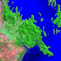
Figure 1.
A Thematic Mapper Image
Enhanced Thematic Mapper Plus (ETM+)
Landsat 7 carries a newly developed Enhanced Thematic Mapper Plus (ETM+) sensor with the same 7 spectral bands as its predecessor, TM, as well as a panchromatic 8th band with 15 metre resolution. ETM+'s thermal band has been improved to 60 metres per pixel. It has a five percent absolute radiometric calibration. Landsat 7 does not carry a Multispectral Scanner sensor. ETM+ gathers data in effectively the same bands, but at a higher resolution.
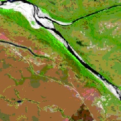
Figure 2.
An Enhanced Thematic Mapper Plus Image.
| Band Number | Spectral Range (Microns) | EM Region | Generalised Application Details |
|---|---|---|---|
| 1 | 0.45 - 0.52 | Visible Blue | Coastal water mapping, differentiation of vegetation from soils |
| 2 | 0.52 - 0.60 | Visible Green | Assessment of vegetation vigor |
| 3 | 0.63 - 0.69 | Visible Red | Chlorophyll absorbtion for vegetation differentiation |
| 4 | 0.76 - 0.90 | Near Infrared | Biomass surveys and delineation of water bodies |
| 5 | 1.55 - 1.75 | Middle Infrared | Vegetation and soil moisture measurements; differentiation between snow and cloud |
| 6 | 10.40- 12.50 | Thermal Infrared | Thermal mapping, soil moisture studies and plant heat stress measurement |
| 7 | 2.08 - 2.35 | Middle Infrared | Hydrothermal mapping |
| 8 (Only on Landsat 7) | 0.52 - 0.90 (panchromatic) | Green, Visible Red, Near Infrared | Large area mapping, urban change studies |
Satellite Characteristics
| Property | Landsat 7 ETM+ | Landsat 5 TM | |
| Ground Sampling Interval (pixel size) |
Bands 1-5 & 7 | 30 x 30 m | 30 x 30 m |
| Band 6 | 60 x 60 m | 120 X 120 m | |
| Band 8 | 15 x 15 m | N/A | |
| Swath width | 185 km | 185 km | |
| Repeat coverage interval | 16 days (233 orbits) | 16 days (233 orbits) | |
| Altitude | 705 km | 705 km | |
| Quantisation | Best 8 of 9 bits | 8 bits (256 levels) | |
| On-board data storage | 375 Gb (solid state) | Magnetic tape failed | |
| Orbit type | Sun-synchronous | Sun-synchronous | |
| Inclination | 98.2° | 98.2° | |
| Equatorial Crossing | Descending node: 10:00am | Descending node: 10:10am | |