|
Figures and Tables
Figure 1. Positions of the continents
during end-Permian time. Red dots denote where extraterrestrial fullerenes
have been reported. In addition, other suggested impact tracers have been
found in Permian-Triassic boundary layers at Graphite Peak, Antarctica,
Meishan, China and Sasayama, Japan including meteoritic debris (8), Fe-Ni-Si
grains (5,8), shocked quartz (4), impact spherules (6). Recently, large
shocked quartz grains (S-1) were found in the Fraser Park, Australia and
Graphite Peak Antarctica, Permian-Triassic boundary layer (yellow dot).
(Permian map modified from Scotese Paleomap Project website: www.scotese.com).
Figure 2. Base map of the offshore
northwestern Canning basin region showing major tectonic elements (i.e.
plateaus, basins, platforms, etc.), the Bedout High with the Lagrange-1
and Bedout-1 exploration wells located on top of the high (red dots) and
two AGSO regional seismic reflection lines (see Figures. 3, 10, S-16)
and the JNOC (JN87-12) seismic line (Figure. 3) that cross over the high
(base map modified from 17).
Figure 3. Interpreted section of the
multichannel seismic line JN87-12 showing correlated ties to Bedout-1
and Lagrange-1 gamma (left) and sonic (right) well logs (modified from
Smith, 1999, 15; location of line in Figure. 2.). Color stratigraphic
horizons represent chronostratigraphic picks (CT-1, early Jurassic, red;
SQ-2, middle Triassic, blue; Unit VIII, late Permian, purple). Triassic
sedimentary rocks overlying Upper Permian (Unit VIII) are thin, however,
all of the units were identified in the Bedout-1 and Lagrange-1 core and
cuttings (S-2).
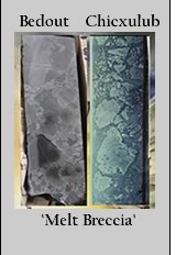
Figure 4. Selected intact 5 cm (wide)
core from Bedout-1 at 3035 to 3037 m (9960 to 9965 feet; top three photos).
These cores display variable sized, angular and subrounded glassy (impact-melted)
fragments set in a matrix that is mostly chloritized and carbonate filled.
The smaller glassy fragments examined in thin section throughout the core
(Figureures S-8-S-14) displayed the same mineralogy and texture as the
larger impact-melted glassy fragments seen in hand specimen. The lower
photo is the Yucatan-6 impact melt breccia that has similar characteristics
to Bedout-1, particularly in hand specimen (Yucatan-6 core photo modified
from www.icdp-online.de/sites/chicxulub/ICDP-Chix/Figureures).
Figure 5. (left) A typical core sample
from the Bedout impact melt breccia at 3052 m (9986 ft.) displays a distribution
of poorly sorted angular and sub-angular clasts in a dark glassy matrix
(scale of picture is 6.5 mm - long dimension). Under higher magnification
(right, inset), the yellowish clast appears to be a partially melted carbonate
clast with fossil ooids characteristic of a marine continental (carbonate
reef) margin environment.
Figure 6. (Top) Photomicrograph in
plane polarized light of Bedout-1 3044 m (9986 ft.) showing a large plagioclase
lath (yellow brown color indicative of alteration) that has been shock
melted. Another lath at upper left has also been shock melted (slide width
550 mm). The shock melted plagioclase glass is in the process of alteration
(green). The matrix is composed of opaque Fe-Ti oxides (black) and albite
(clear). The lower picture is the same view under crossed nicols. All
of the plagioclase laths are now extinct (black) at all orientations indicating
conversion to maskelynite, shock melted glass that suggests an impact.
Note that the two maskelynite laths are at slightly different orientations
yet both are completely extinct.
Figure 7(A). Photomicrograph of shock
melted fragments of spherulitic glass from Bedout 3044 m (9986 ft.) set
in a matrix of dark glass. Similar spherulitic alteration of glass has
been identified in other terrestrial craters (e.g. Chicxulub, Sudbury).
Width of slide is 1.0 mm.
(B). Back Scattered Electron Image
of another spherulitic glass fragment from Bedout 3044 m (9986 ft.). Table
1, Analysis #22. Similar textures have been observed in BSE images of
the Chicxulub suevite. Scale bar is 50 mm.
(C). Back Scattered Electron Image
of high silica glass from Bedout 3044 m (9986 ft). The large grain of
nearly pure silica (analyses #22 and #24) in the center of the image is
set in a matrix of plagioclase, altered glass and Fe-Ti oxides. Note the
dark and light areas of the BSE image that correspond to different levels
of impurities in the silica glass. Ordinary volcanic processes cannot
produce glass of >85% silica. Scale bar is 50 mm.
Figure 8. Shock melted plagioclase
grains set in a matrix of albite, Fe-Ti Oxides and glass that is altering
to chlorite 3044 m (9986 ft.). The rim of the large grain in the upper
right is crystalline plagioclase (visible in X-nicols in Figureure inset)
with a composition of An50 (analysis 3 in Table S-1). The core of this
grain is isotropic glass with a similar composition of An50 plagioclase
(analysis 4). Single plagioclase lath (left of center) contains andesine
plagioclase (An50) (right side of grain, point 6), diaplectic glass in
the center and pure albite (point 7) on the left.
Figure 9. Ar/Ar step-heating ages
for the Lagrange-1 a plagioclase separate at 3255 m (10,679 ft.) from
the top of the Bedout High indicate an age of 250.1 ± 4.5 Ma.
Figure 10. Reinterpreted 1994 AGSO
multichannel seismic line s120-01. This interpretation shows the central
uplift of the inferred Bedout impact structure deforming end-Permian (dark
blue line) and older sequences (Pre-Permian, orange dashed line and Top
Precambrian basement, red dashed line), overprinted by younger faults
associated with late-Triassic to mid-Jurassic rifting. The "pre-Permian
strata", are inferred only from seismic character (15), yet appear
to show uplift with the basement. These reflectors are carried from wells
in the adjacent onshore Canning basin.
Figure 11. (left) Blow-up of isostatic
residual gravity model over Bedout as compared with (right) Bouguer gravity
over Chicxulub (modeled after 12) at approximately the same scale. Diameters
of the central uplift (~40-60 km) and transient crater (~100 km, dashed
circle) inferred from the gravity model for Bedout are similar in size
to these same features inferred for the Chicxulub impact structure. Gravity
signature at Bedout is significantly reduced and more subdued than Chicxulub
owing to its greater depth of burial (Bedout gravity model by Andrew Lockwood,
GSWA, Perth Australia).
Figure 12. Shocked quartz in the
K/T (yellow circles) and P/Tr (red crosses) boundaries. Shown is the distribution
of the maximum grain size of shocked quartz with distance from the two
proposed source craters (Chicxulub for K/T and Bedout for P/Tr). Solid
line is a power regression through the K/T data (42).
|