|
Geophysical
Evidence
Confirmation that the Bedout High consists of an impact breccia
and melt sheet led us to re-interpret some seismic lines provided
by the Australian Geological Survey (AGSO; 18) including line
S120-01 (Fig. 10 below), originally interpreted by Gorter
(13,14).
 |
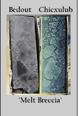
| Figure 10. Re-interpreted 1994 AGSO
multichannel seismic line s120-01. This interpretation
shows the central uplift of the inferred Bedout impact
structure deforming end-Permian (dark blue line) and older
sequences (Pre-Permian, orange dashed line and Top Precambrian
basement, red dashed line), overprinted by younger faults
associated with late-Triassic to mid-Jurassic rifting.
The “pre-Permian strata”, is inferred only
from seismic character (15), yet appear to show uplift
with the basement. These reflectors are carried from wells
in the adjacent onshore Canning basin. Click
here for a larger view |
Our revised chronostratigraphy for line S120-01 includes
the Lagrange-1 and Bedout-1 stratigraphic sections, correlation
with adjacent onshore seismics and wells (31) and the Ar-Ar
and K-Ar dating of the melt breccia. The top of the Permian
(blue line) is conformable with the Bedout High whereas Triassic
sediments (light green) unconformably onlap onto the structure
(Fig. 10, S-15 below).
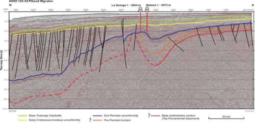 |
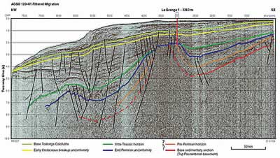
S-15 1994 AGSO multichannel seismic
line S120-04 showing both wells, a more pronounced annular
depression, central uplift and end-Permian (blue line)
and older sequences (orange, Pre-Permian; red, Precambrian).
The reflectors for the older sediments are not well resolved
as the lines are carried toward the central uplift and
in the deeper Precambrian basement and appear dashed on
the interpretation.
Click
here for a larger view |
The revised seismic section shows a broad uplifted core of
basement (red line) 40 to 60 km in diameter elevated a minimum
of 6 to 9 km. The “pre-Permian” strata (Fig.
10) inferred only from seismic character correlations
(15), are not well imaged in the seismic data and yet appear
to show uplift with the basement core. Alternatively, as the
deeper material has yet to be sampled and dated, these sequences
could all be end-Permian crater-fill impact debris. We also
detect a slight uplift of Permian and earlier strata at a
radius of ~100 km from the center of the Bedout High, but
it is not clear that this is a concentric feature. A 2D-velocity
model derived from OBS wide-angle reflection and refraction
data collected along the S120-01 line (32) reveal a central
uplift beneath the Bedout high, with some 6 to 7 km of vertical
structural relief on mid-crustal iso-velocities. Although
less well resolved, the data also suggest possible variations
in Moho depth beneath Bedout (33). It is difficult to assess
though whether this Moho topography is, like Chicxulub, the
result of the dynamic effects of the crater (and Bedout High)
forming process extending down to the base of the crust (33-35),
or is the result of later rifting of the continental margin.
The Bedout structure was emergent in the Early to Middle
Triassic and probably deeply eroded. Onshore in the Canning
Basin much of the Permian and Early Triassic section is missing:
over 0.5-1 km of section overall, and as much as 2 km on topographic
highs (36). We do not know the depth of erosion at Bedout,
but it is probable that the unconformity at the top of the
Permian represents missing section. The Lagrange-1 well extends
for several hundred meters through the impact melt breccia,
but it is uncertain how much more of the High is actual impact
melt breccia. The isostatic-residual gravity model for the
Bedout structure and the Bouguer gravity over Chicxulub both
show a semi-circular gravity low surrounding the expression
for the central peak (Fig. 11 below).
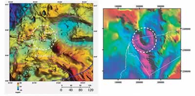 |
| Figure 11. (left) Blow-up of isostatic
residual gravity model over Bedout as compared with Bouguer
gravity over Chicxulub (modified after 12) at approximately
the same scale. Diameters of the central uplift (~40km)
and transient crater (~100km, dashed circle) inferred
from the gravity model for Bedout are similar in size
to these features inferred for the Chicxulub impact structure.
Gravity signature at Bedout is significantly reduced and
more subdued than Chicxulub owing to its greater depth
of burial (Bedout gravity model by Andrew Lockwood, GSWA,
Perth Australia). Click
here for a larger view |
Unfortunately, the resolution of the offshore gravity data
is not of sufficient quality to obtain a vertical derivative
image generally used to highlight the more subtle gradients,
and assist in assessing the geomorphometric parameters, including
size, of the Bedout structure. The outer edge of the gravity
low has a diameter of ~100 km and is similar in size to the
more well resolved Chicxulub gravity low (Fig. 11).
Comparisons of the Bedout
Structure with other Impact Structures
As first noted by Gorter (13,14), the geophysical expression
of the Bedout High is similar to the central uplift in other
large impact craters. Fracturing and brecciation, caused by
the impact of large meteorites with the crust, produce a characteristic
negative gravity anomaly surrounding a gravity-high, a feature
that led to the initial discovery of Chicxulub (e.g., 12).
Such an anomaly exists at Bedout (Fig.
11), but it is somewhat obscured by other complex crustal
features derived from younger tectonic overprinting (e.g.
Triassic and Jurassic). The gravity high in the center of
large terrestrial craters is due to the central uplift elevating
denser basement rocks. At Bedout the gravity high is clearly
associated with a structural high. The central uplift at Chicxulub
is poorly imaged seismically, consists mostly of ~6-7 km uplift
of mid-crustal iso-velocities and is ~40-60 km in diameter
(33). These dimensions compare well with the Bedout High,
suggesting Bedout may be about the same size as Chicxulub
(~200 km diameter). The slight uplift noted at a radius of
~100 km at Bedout, may be a subtle expression of the outer
rim, but this is speculative. If the Bedout High is a central
uplift similar to the one at Chicxulub, then the erosion at
Bedout could be extensive, as the top of the Chicxulub central
uplift lies about 3.5 km below the crater floor (37).
|