|
The cause of the catastrophic mass extinction at the end of the Permian
has been the focus of considerable debate. Becker et al., (1-3) and others
(4-10) have presented evidence that a major impact was associated with
the extinction of > 90% of marine taxa. The evidence includes fullerenes
with extraterrestrial helium and argon (1,7), meteorite fragments (8),
Fe-Ni-Si “metamorphosed grains” of probable meteoritic origin
(5,8,9), Fe-Ni metals with impact spherules (6,10) and shocked quartz
(4).
Acceptance that an impact accompanied the K/T extinction increased dramatically
with the discovery of the Chicxulub crater (11,12). We searched for a
Permian-Triassic (P/Tr) boundary impact crater in the southern hemisphere
that once comprised the supercontinent of Gondwana because the impact
evidence is most abundant in continents from this region (e.g. Australia,
Antarctica). Gorter, based on the study of a single seismic line (13,14),
suggested that the Bedout (“Bedoo”) High offshore of Northwestern
Australia might be the central uplift of a large end-Permian impact crater.
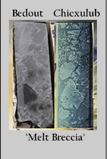
In this paper, we describe the Bedout structure and present evidence from
drill cores, additional seismic and gravity data and Ar/Ar dating of plagioclases
that Bedout is a large buried end-Permian impact crater and possibly the
source of the P/Tr ejecta deposits distributed globally (Fig.
1, S-1 below).
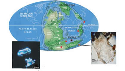 |
| Figure 1 - Positions of the
continents during end-permian time. Red clots denote where extraterrestrial
fullerenes have been reported (1-3). In addition, several other impact
tracers have been found in the Permian-Triassic boundary layers at
Graphite Peak, Meishan, China and Sasayama, Japan including meteoritic
debris (8), Fe-Ni-Si grains (5,8), shocked quartz (4), impact spherules
(6). Recently, large quartz grains (S-1) were found
in the Fraser Park, Australia (yellow dot) and Graphite Peak, Antarctica,
Permian-Triassic boundary layers. (Permian map modified from Scotese
Paleomap Project website: www.scotese.com)
Click
here for larger view) |
 |
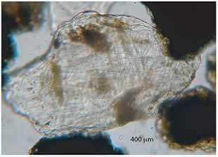 |
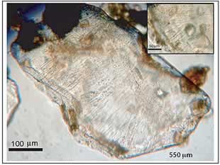
| S-1 Large shocked quartz grains with
planar deformation features (PDFs) identified in the Fraser Park,
Sydney Basin Permian-Triassic boundary layer. Inset in upper photo
shows close-up of intersecting PDFs. Quartz grains are mounted in
oil and photographed in plane polarized light.
Click here for larger view) |
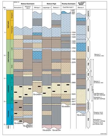
Geology of the Bedout Structure
The Bedout High is part of the Roebuck basin that forms the northwestern
continental margin of Australia (Fig. 2 below).
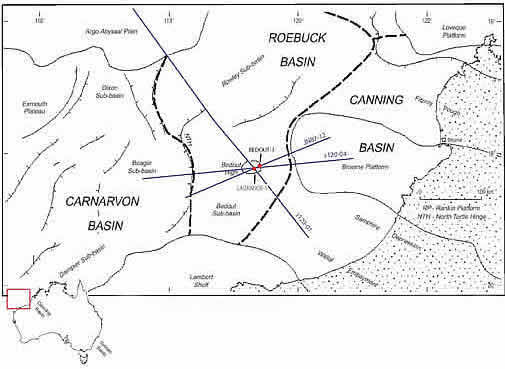
Figure 2. Base map of the offshore northwestern
Canning basin region showing the major tectonic elements (i.e. plateaus,
basins, platforms, etc.), the Bedout High with the Lagrange-1 and
Bedout-1 exploration wells located on top of the high (red dots) and
two AGSO regional seismic reflection lines (see
Figs. 10, S-15) and the JNOC (JN87-12;)
seismic line (Fig. 3) that cross over the high
(base map modified from 17).
Click here for larger
view) |
Existing studies of the structure include two regional seismic surveys
conducted by the Australian Geological Survey (AGSO) and the Japan National
Oil Company (JNOC) and two exploratory wells drilled 9 km apart on the
top and flank of the Bedout High, Bedout-1 and Lagrange-1, that extend
to depths of 3052 m (9986 ft.) and 3273 m (10,738 ft.), respectively (Fig.
3, S-2).
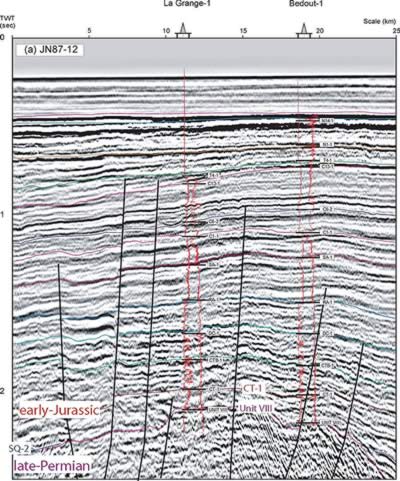 |
Figure 3. Interpreted
section of the multichannel seismic line JN87-12 showing correlated
ties to Bedout-1 and Lagrange-1 gamma (left) and sonic (right) well
logs (modified from Smith, 1999, 15 ; location of line in
Fig. 2). Color stratigraphic horizons represent chronostratigraphic
picks (CT-1, early Jurassic, red; SQ-2, middle Triassic, blue; Unit
VIII, late Permian, purple). The < >Triassic sediments overlying
the late Permian (Unit VIII) are thin, however, all of the units
(late, middle, early) were identified in the Bedout-1 and Lagrange-1
core and cuttings (S-2).
Click here for larger view)
|
| |
|